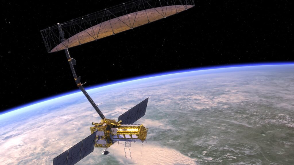
March 2025 – The much-anticipated NISAR satellite, a joint venture between NASA and ISRO, is set for launch, promising groundbreaking advancements in Earth observation technology.
The NISAR satellite (NASA-ISRO Synthetic Aperture Radar) is designed to monitor surface changes, natural disasters, climate patterns, and ecosystem disturbances. Originally planned for a 2024 launch, the mission faced delays due to modifications in its deployable antenna. Officials have now confirmed that the NASA-ISRO radar satellite will lift off in March 2025 from the Satish Dhawan Space Centre in Sriharikota, India.

A Revolutionary Earth Observation Mission
The NASA-ISRO radar satellite is the first Earth observation mission to incorporate dual-frequency synthetic aperture radar technology. Developed through a collaboration between NASA and ISRO, the satellite will provide high-resolution imaging of Earth’s surface, regardless of weather conditions or time of day.
Latest Updates on the NISAR Satellite
- Launch Schedule: After undergoing crucial upgrades, the NASA-ISRO radar satellite is now slated for a March 2025 launch aboard ISRO’s GSLV Mk II rocket.
- Scientific Expansion: The mission will now include real-time soil moisture tracking, offering crucial insights for global agriculture and water resource management.
- Disaster Response Applications: The NISAR satellite will provide near-instantaneous data on earthquakes, tsunamis, and landslides, supporting disaster management teams worldwide.
Key Objectives of the NISAR Satellite
- Monitoring Natural Disasters: The NISAR satellite will help detect earthquakes, landslides, and other geophysical events.
- Tracking Climate Change: Scientists will use the satellite’s data to study melting glaciers, rising sea levels, and deforestation.
- Agricultural and Forestry Applications: The NASA-ISRO radar satellite will assist in crop monitoring, soil moisture analysis, and forest conservation.
- Urban and Infrastructure Planning: Governments will use its high-resolution imaging to manage sustainable urban growth and infrastructure stability.
Technical Features of the NASA-ISRO radar satellite
The NISAR satellite boasts state-of-the-art radar technology:
- L-band Radar (NASA): Penetrates vegetation and soil for subsurface monitoring.
- S-band Radar (ISRO): Provides high-resolution images of land surface changes.
- 24-day Repeat Cycle: Ensures frequent and consistent imaging of Earth’s surface.
- Global Coverage: The satellite will revisit the same location every 12 days for precise tracking.
NASA and ISRO’s Role in the NISAR
- NASA: Developed the L-band radar, contributes data processing technology, and supports scientific research.
- ISRO: Developed the S-band radar, handles satellite integration, and will oversee launch operations.
Implications of the NISAR Satellite’s Launch
Experts believe the NASA-ISRO radar satellite will have a transformative impact on global science and policy-making:
- Climate Research: The satellite will help refine climate models by monitoring changes in ice sheets and sea levels.
- Disaster Management: Emergency response teams will benefit from real-time data on earthquakes and other hazards.
- Environmental Protection: The NASA-ISRO radar satellite will track deforestation and land degradation to aid conservation efforts.
- Agriculture: Farmers and policymakers will gain insights into soil moisture levels and crop health.
NASA-ISRO NISAR Satellite Set for Early 2025 Launch to Revolutionize Earth Observation
In a significant milestone for global space collaboration, the NASA-ISRO Synthetic Aperture Radar (NISAR) satellite is scheduled for launch in early 2025. This joint venture between the National Aeronautics and Space Administration (NASA) and the Indian Space Research Organisation (ISRO) is poised to transform Earth observation capabilities with its cutting-edge radar technology.
NISAR, the first satellite to feature both NASA’s L-band radar and ISRO’s S-band radar, will be launched from the Satish Dhawan Space Centre in Andhra Pradesh aboard ISRO’s Geosynchronous Satellite Launch Vehicle Mark II. Developed under a 2014 agreement between the U.S. and India, the mission aims to map the Earth every 12 days, delivering continuous and precise data on key environmental and geological changes.
The satellite’s advanced radar payload is supported by a 12-meter drum-shaped, wire-mesh reflector—the largest of its kind in space—along with a gold-colored thermal blanket to maintain operational temperature. The spacecraft bus will handle power, communication, navigation, and orientation for the satellite.
Technologically, NISAR brings together dual-frequency radar systems:
- L-band Radar (NASA): Ideal for detecting ground movements through dense vegetation, making it vital for monitoring volcanoes and seismic zones.
- S-band Radar (ISRO): Enhances surface observation accuracy, operating at 2–4 GHz with an 8–15 cm wavelength.
Applications and Impact
NISAR will provide high-resolution data regardless of weather conditions or daylight, capturing both horizontal and vertical movements of Earth’s surface. Key applications include:
- Disaster Mitigation: Early tracking of earthquakes, landslides, and volcanic activity.
- Environmental Monitoring: Observing forests, wetlands, farmlands, and deforestation trends.
- Infrastructure Assessment: Monitoring urban development and detecting oil spills.
- Climate Research: Measuring changes in sea level, ice mass, and groundwater reserves.
By offering consistent, detailed insights, NISAR will empower policymakers, scientists, and environmentalists with data-driven tools for sustainable planning and disaster resilience. To know more visit your trusted site Hours of news.


